Home
Login
Kings Park Heritage Museum
Browse Our Rooms
Album list
Last uploads
Last comments
Most viewed
Top rated
My Favorites
Search
Home
>
Historic Kings Park
>
Maps
FILE 2223/2238
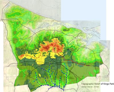
Relief Map of Kings Park
Map made in 2002 from 1954-56 USGS Topographic Maps.
Rate this file
(No vote yet)
Javascript must be enabled in order to vote
File information
Filename:
1956_kp_topo_2.jpg
Album name:
dflynn
/
Maps
Keywords:
Kings Park
/
topo map
/
Fort Salonga
/
San Remo
/
Sunken Meadow
Filesize:
653 KiB
Date added:
Jul 27, 2013
Dimensions:
2047 x 1647 pixels
Displayed:
565 times
URL:
http://kpheritagemuseum.net/cpg/displayimage.php?pid=17
Favorites:
Add to Favorites