Home
Login
Kings Park Heritage Museum
Browse Our Rooms
Album list
Last uploads
Last comments
Most viewed
Top rated
My Favorites
Search
Home
>
Historic Kings Park
>
Maps
FILE 65/67
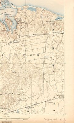
USGS Topographic Map, west KP and Northport, Commack, etc.
Published c1903.
Rate this file
(No vote yet)
Javascript must be enabled in order to vote
File information
Filename:
usgs_190x_map_npt.jpg
Album name:
dflynn
/
Maps
Keywords:
Kings Park
Filesize:
632 KiB
Date added:
Jul 27, 2013
Dimensions:
1243 x 2047 pixels
Displayed:
575 times
URL:
http://kpheritagemuseum.net/cpg/displayimage.php?pid=16
Favorites:
Add to Favorites